MauritaniaDownload light PDF version
Overview
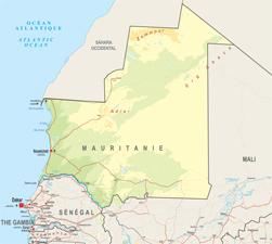
Serving as a point of contact between North and Sub-Saharan Africa, Maurintania was a member of both the Arab Maghreb Union (UMA) and the Economic Community of West African States (ECOWAS) for a long period time. It decided to leave ECOWAS in 1999 but showed renewed interest in the organisation in 2007 and signed a partnership agreement. It is also grouped with the ECOWAS group in negotiations for an Economic Partnership Agreement (EPA) with the European Union. Mauritania has actively sought to foster good relations with its immediate Sub-Saharan neigbours (Mali and Senegal), particularly through joint efforts under the Organisation for the Development of the Senegal River (OMVS). The projects realised by the OMVS – construction of the Manantali and Diama Dams, improving the navigability of the river and improving electricity access in the valley – are used as models throughout West Africa. The serious crisis in relations with Senegal in 1989 should be seen as an unfortunate historical accident
Only 0.5% of land in Mauritanian is arable, making it an essentially Saharan country that is particularly vulnerable to the consequences of the desertification that has been observed in the Sahel for several decades. Parts of its population were made environmental refugees during the droughts of 1973 and 1984 at a time when such an expression did not even exist. In order to better confront this challenge, Mauritania joined together with the other Sahelian countries in West Africa and was one of the founding members for the Inter-State Committee for Drought Control in the Sahel (CILSS). The country began exporting oil in 2006 in the hopes of diversifying the economy beyond the traditional mining, fishing and livestock sectors.
Mauritania is also involved in the fight agains AQMI, whose activities, although centered in Northern Mali, also cover a large part of its territory.
Institutional Framework
| Government type: | Military junta |
| Constitution: | 12 July 1991
|
| Legal system: | mixed legal system of Islamic and French civil law |
| Administrative division | 13 regions (wilayas, singular - wilaya): Adrar, Assaba, Brakna, Dakhlet Nouadhibou, Gorgol, Guidimaka, Hodh ech Chargui, Hodh El Gharbi, Inchiri, Nouakchott, Tagant, Tiris Zemmour, Trarza |
| Executive branch: |
|
| Legislative branch: | bicameral legislature consists of the Senate or Majlis al-Shuyukh (56 seats; 53 members elected by municipal leaders and 3 members elected for Mauritanians abroad to serve six-year terms; a portion of seats up for election every two years) and the National Assembly or Al Jamiya Al Wataniya (95 seats; members elected by popular vote to serve five-year terms) |
| Judical branch: | Supreme Court or Cour Supreme; Court of Appeals; lower courts |
| Political parties: |
|
| Suffrage: | 18 years of age; universal |
| Elections: | following the August 2008 coup, the High State Council planned to hold a new presidential election in June 2009; the election was subsequently rescheduled to 18 July 2009 following the Dakar Accords, which brought Mauritania back to constitutional rule; under Mauritania's constitution, the president elected by popular vote for a five-year term; election last held on 18 July 2009 (next to be held by 2014) |
| Election results: | percent of vote - Mohamed Ould Abdel AZIZ 52.6%, Messaoud Ould BOULKHEIR 16.3%, Ahmed Ould DADDAH 13.7%, other 17.4% |
| Central bank: | Central Bank of Mauritania |
| Military branches: | Mauritanian Armed Forces: Army, Mauritanian Navy (Marine Mauritanienne; includes naval infantry), Islamic Air Force of Mauritania (Force Aérienne Islamique de Mauritanie, FAIM) (2010) |
| Military age and obligations: | 18 years of age (est.); conscript service obligation - 2 years; majority of servicemen believed to be volunteers; service in Air Force and Navy is voluntary (2006) |
| Membership in regional organisations: | AfDB, AU, CILSS, OMVS, Cen-sad |
Regional Indicators
- Land boundaries: 5074 km
- Border Countries: Algeria 463 km, Mali 2,237 km, Senegal 813 km, Western Sahara 1,561 km
- Coastline: 754 km
- Airports: 28 with paved runways: 9 (2010)
- Railways: 728 km
- Roadways: 11 066 km; paved: 2 966 km;unpaved: 8 100 km (2006)
- Waterways:---
- Ports and terminals: ----
Demographic Trends
- Population 2010: 3 460 000
Projection 2050: 7 085 000
Population < 15 years: 1 377 080 (39.8% *3 460 000 =1 377 080)
Population density: 3/ sq.km
Urban agglomeration: none
Annual Growth: 2.54% (2005-2010) > 2.24 (2010-2015)
Woman fertility (children per women): 4.71 (2005-2010)> 4.36 (2010-2015)
Median age: 19.8
Dependency ratio: 74
Migration and Mobility
- Number of emigrants (2010): 118 000 =3.5% of pop
- Number of immigrants (2010): 99 200 = 2.9% of pop
- Top destination countries: Senegal, Nigeria, Côte d’Ivoire, France, Spain, Mali, The Gambia, the United States, the Republic of Congo, Germany
- Refugees within country: 27 000 (2009)
Economic Indicators
- GDP total: USD 8 250 million
- GDP per capita: USD 2 451
- % of regional GDP: 1.5%
- Annual Growth: -1.2%
- Average growth (2002-10): 4.1%
- Currency: Ouguiyas
- Inflation Rate: 2.2%
- Main Exports: iron ore, fish and fish products, gold, copper, petroleum
- Main Export partners: China 43.8%, Italy 9.6%, Japan 7.5%, Cote d'Ivoire 6.1%, Spain 5.5%, Netherlands 4.3% (2009)
- Main Imports: machinery and equipment, petroleum products, capital goods, foodstuffs, consumer goods
- Main import partners: France 13.7%, China 12.6%, Netherlands 9.9%, Brazil 5.3%, Belgium 4.7% (2009)
- Trade balance: USD -83 million
- Foreign Direct Investment inflows: USD -38 million
- Estimated Diaspora Remittances 2009: 0.1% of GDP
- = USD 2 million
- = USD 0.57
- = USD per capita
- ODA received: USD 287 million
- =as % of GDP: 3.47%
- =per capita: USD 82.94
- Category: Lower middle income (2011)
- Public Spending on:
- Education as a percentage of total government expenditure (2000-2007): 10.1%
- Health as a percentage of total government expenditure (WHO, 2009): 5.3%
- Military: 115 million USD = 3.8% of GDP (2009)
- External Debt: USD 3123 million
- Debt service (as % of Exports 2010e): 5.5%
- Public finance (% of GDP 2009):
- Revenue and grants: 25.5%
- Expenditures and net lending: 30.6%
- Overall balance: -5.1
- IMF Adjustment Programme: yes
- Corruption Perception Index (xx/10): 2.3 (143/178)
- Index of Economic Freedom (xx/100): 52.1 (134/179)
- WB Doing Business index: 165/183
- Ibrahim African Governance index: 50.8
Food Security
| Global Hunger Index (IFPRI, 2011): | 12.7 |
| Food supply (kcal per capita/day) | 2 823 |
| Number of people undernourished: | 0.2 million |
:Percentage of people undernourished: | 7% |
| Child malnutrition, underweight: | 32% |
| Child malnutrition, stunting: | 35% |
Land use
| Land area (1 000 ha): | 103 070 |
| Agricultural land area (1 000 ha): | 39 651 |
Arable land (1 000 ha): | 400 |
| Permanent crops (1 000 ha): | 11 |
| Pastures (1 000 ha): | 39 250 |
| Irrigated land (1 000 ha): | 45 |
| Share in total water use by |
|
| Forest area (1000 ha): | 242 |
Source: FAOStat and FAO Country Profile
Social Indicators
Religion & Ethnicity
- Ethnic Groups : mixed Moor/black 40%, Moor 30%, black 30%
- Major Religions: Muslim 100%
Health
- Life Expectancy: 56.6 (2005-2010)
- Under-five Mortality Rate (per 1000 live births) (2008): 118
- Number of physicians (for 100 000 people) (2004): 10.9
- Hospital Beds (for 10 000 people): 4 (2006)
- Estimated HIV prevalence (2007): N.A
Education:
- Adult literacy rate: (% age 15 and above):--
- Youth Literacy Rate: 67
- Primary Enrolment Rate: 76.6
- Tertiary Students:--
- University attendance Ration:--
ICT & Media:
- Internet Access (per 100 inhabitants): 2.28
- Internet domain: .mr
- International dialing code: 222
- Mobile line (per 100 inhabitants) 2009: 66.32
- Main telephone line (per 100 inhabitants) 2009: 2.26
Basic Services:
- Access to electricity 2007: kWh 688 millions
- Water supply coverage 2008: 49% (urban 52%, rural 47%)
- Sanitation coverage2008: 26% (urban 50%, rural 9%)