Gambia (The)Download light PDF version
Overview
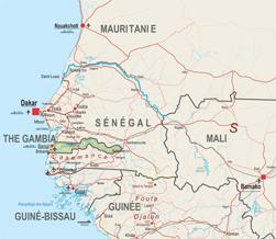
The smallest country in continental Africa, The Gambia gained independence from the United Kingdom in 1965. It is also the third smallest West African country in terms of population, ranking after Cape Verde and Guinea-Bissau.
The Gambia’s total population lives no more than 25 km from its sole land border. Senegal, its only border country, surrounds it on the north, south and east. The Gambia is intrinsically regional. It was part of the Senegambia Confederation with Senegal until 1989 (“Sénégambie”) and its population is integrated into the large ethno-linguistic groups within Senegal (Malinke in the East and Wolof to the West). The Mouride Brotherhood, whose capital is in Touba, Senegal, has a very strong and powerful presence in the country.
The country trades extensively with both Senegal and Guinea-Bissau, particularly in cereals, livestock, and imports of consumer goods. Moreover, the common natural environment shared by The Gambia, the Casamance (southern Senegal) and Guinea-Bissau have made the area highly interdependent and strongly interconnected.
Institutional Framework
| Government type: | Republic |
| Constitution: | approved by national referendum 8 August 1996; effective 16 January 1997 |
| Legal system: | mixed legal system of English common law, Islamic law, and customary law |
| Administrative division | 5 divisions and 1 city*: Banjul*, Central River, Lower River, North Bank, Upper River, Western |
| Executive branch: |
|
| Legislative branch: | unicameral National Assembly (53 seats; 48 members elected by popular vote, 5 appointed by the president; members to serve five-year terms) |
| Judical branch: | Supreme Court |
| Political parties: |
|
| Suffrage: | 18 years of age; universal
|
| Elections: | president elected by popular vote for a five-year term (no term limits); election last held on 24 November 2011 (next to be held in 2016) |
| Election results: | Yahya JAMMEH reelected president; percent of vote - Yahya JAMMEH 71.5%, Ousainou DARBOE 17.4%, Hamat BAH 11.1% |
| Central bank: | Central Bank of Gambia (CBG) |
| Military branches: | Office of the Chief of Defense Staff: Gambian National Army (GNA), Gambian Navy (GN) (2010) |
| Military age and obligations: | 18 years of age for voluntary military service; no conscription (2010) |
| Membership in regional organisations: | AfDB, AU, ECOWAS, CILSS, OMVG, Ced-sad |
Regional Indicators
- Land boundaries: 740 km
- Border countries: Senegal (740 km)
- Coastline: 80 km
- Airports: 1 with paved runways: 1 (2010)
- Railways: -----
- Roadways: 3 047km; paved: 723km; unpaved: 3 019 km (2004)
- Waterways: 390 km (on River Gambia; small ocean-going vessels can reach 190 km) (2010)
- Ports and terminals: Banjul
Demographic Trends
- Population 2010: 1 728 000
- Projection 2050: 4 036 000
- Population < 15 years: 760 320 (44% *1 728 000 = 760 320)
- Population density: 153/ sq.km
- Urban agglomeration: none
- Annual Growth: 2.75% (2005-2010) > 2.68% (2005-2010)
- Woman fertility (children per women): 5.10 (2005-2010)> 4.69 (2010-2015)
- Median age: 17.8
- Dependency ratio:133
Migration and Mobility
- Number of emigrants (2010): 64 900 =3.7% of pop
- Number of immigrants (2010): 290 100 = 16.6% of pop
- Top destination countries: Spain, the United States, Nigeria, Senegal, the United Kingdom, Germany, Sweden, Sierra Leone, Norway, France
- Refugees within country: 14 800 (2009)
Economic Indicators
- GDP total 2010: USD 3525 million
- GDP per capita: USD 2013
- Annual Growth: 5.2%
- Average growth (2002-10): 5.2%
- Currency: Dalasis (GMD)
- Inflation Rate: 4.6%
- Main Exports: peanut products, fish, cotton lint, palm kernels
- Main Export partners: India 47.5%, France 12.6%, China 10.9%, UK 7.4% (2009)
- Main Imports: foodstuffs, manufactures, fuel, machinery and transport equipment
- Main Import partners: China 22.1%, Senegal 9.3%, Brazil 8.4%, Cote d'Ivoire 4.7%, Netherlands 4.6%, India 4.5%, US 4.4% (2009)
- Trade balance: USD -203 million
- Net Foreign Direct Investment inflows: USD 47 million
- Estimated Diaspora Remittances 2009: 7.9% of GDP
- = USD 60 million
- = 34.72 per capita
- ODA received: USD 128 million
- =as % of GDP: 36.31%
- =per capita: USD 74.07
- Category: Low income (2011)
- Public Spending on:
- Education as a percentage of total government expenditure (2000-2007): 8.9%
- Health as a percentage of total government expenditure (WHO, 2009): 8.7%
- Military: 4.6 million USD =0.8% GDP (2007)
- External Debt: USD 330 million
- Debt service (as % of Exports 2010e): 31.2%
- Public finance (% of GDP 2009):
- Revenue and grants: 19%
- Expenditures and net lending: 22%
- Overall balance:-3
- IMF Adjustment Programme: yes
- Corruption Perception Index (xx/10) 2010: 3.2 (86/178)
- Index of Economic Freedom (xx/100): 57.4 (105/179)
- WB Doing Business index: 146/183
- Ibrahim African Governance index: 55.2
Food Security
| Global Hunger Index (IFPRI, 2011): | 15 |
| Food supply (kcal per capita/day) | 2 345 |
| Number of people undernourished: | 0.3 million |
:Percentage of people undernourished: | 19% |
| Child malnutrition, underweight: | 20% |
| Child malnutrition, stunting: | 22% |
Land use
| Land area (1 000 ha): | 1 000 |
| Agricultural land area (1 000 ha): | 665 |
Arable land (1 000 ha): | 390 |
| Permanent crops (1 000 ha): | 5 |
| Pastures (1 000 ha): | 260 |
| Irrigated land (1 000 ha): | 2 |
| Share in total water use by |
|
| Forest area (1000 ha): | 480 |
Source: FAOStat and FAO Country Profile
Social Indicators
Religion & Ethnicity
- Ethnic Groups : Mandinka 42%, Fula 18%, Wolof 16%, Jola 10%, Serahuli 9%, non-African 1%, other 4% (2003 census)
- Major Religions: Muslim 90%, Christian 8%, indigenous beliefs 2%
Health
- Life Expectancy: 55.8 (2005-2010)
- Child Mortality (infant deaths per 1,000 live births) : 76.5
- Under-five Mortality Rate (per 1000 live births) (2008): 106
- Number of physicians (for 100 000 people) (2004): 10.2
- Hospital Beds (for 10 000 people): 8 (2005)
- Estimated HIV prevalence (2007): 0.9%
Education:
- Adult literacy rate: (% age 15 and above): 45,3% (2008)
- Youth Literacy Rate: 64,1% (2008)
- Net Primary Enrolment Ratio: 220931 (2008)
- Net Secondary Enrolment Ration: 105237 (2008)
- Tertiary Students: N.A
- University attendance Ration: 1,2% (2004)
ICT & Media:
- Internet Access (per 100 inhabitants): 7.63
- Internet domain: .gm
- International dialing code: 220
- Mobile line (per 100 inhabitants) 2009: 84.04
- Main telephone line (per 100 inhabitants) 2009: 2.87
Basic Services
- Access to electricity 2007: kWh 223 millions
- Water supply coverage 2008: 92% (urban 96%, rural 86%)
- Sanitation coverage2008: 67% (urban 68%, rural 65%)